Goto main content

News

Result: (151) Showing 91 - 120

N6 webmap norsk web

Biotope map for Nordland VI published

05.12.2013

MAREANO scientists have now produced a biotope map for the Nordland VI area in Northern Norway. "Biotope" is a term used to describe the main biological communities and the physical environment they inhabit.  MAREANO video data were to determine the biological communities and this information was put together with bathymetry, terrain and geological data to model the overall distribution of biotopes.

Børstemark

A bristle worm shuts the door on us

21.11.2013

You'll never have seen anything like this before! A small bristle worm, just a few centimetres long, suddenly decides to withdraw into its house, closing the door tightly behind it.

R1270VL1309 still e 00 14 36 Gravende tangloppe Neohela i sin hule ytre Mbank 950m

Deepsea ambush

23.10.2013

The small crustacean Neohela monstrosa waits patiently in its cave for small animals to pass, so that it can pounce on them and eat them. In the video you can see what happened to a krill that decided to take a breather right outside the cave.

Hardbunns korallskog med risengrynkorall

Living in a landslide

15.10.2013

Cruise diary: MAREANO is currently mapping the southern part of Storegga, along the shelf edge and slope areas where a series of underwater landslides have occurred, most recently the famous Storegga slide, which dramatically altered the underwater landscape here some 8200 years ago.

Børstemark

In deep water off Mørebankene

07.10.2013

The last piece of the bottom areas on and around Mørebankene are now surveyed by MAREANO after two weeks work aboard the research ship G.O. Sars (see sampling stations in the map below). A varying benthic fauna living within old avalanches and on plains has been videotaped and sampled. The rate is now set for the waters off the coastline from Kristiansund to Haltenbanken.

R1233VL1269 still e 00 00 47

MAREANO's autumn cruise is underway

27.09.2013

Cruise diary: On Sunday 22nd September the research vessel G.O. Sars sailed from Kristiansund to begin MAREANO's third cruise in 2013. During this cruise several areas off the coast of Møre and Trøndelag in mid-Norway will be documented using underwater video and various equipment for sampling the seabed.

Sjøfjær (Pennatula)

More vulnerable seapens discovered

27.09.2013

Two new areas with high concentrations of seapens have been documented in the Barents Sea, near the coast of the county of Finnmark. Once we have analysed our videos of these areas, we will know whether the concentrations are high enough for both areas to be defined as vulnerable under the international OSPAR Convention. The videos were taken during the expedition that we completed in August.

Sjøstjerne

Barents Sea South East – mother nature’s pantry

27.09.2013

Cruise diary: The MAREANO project has mapped one of the most bountiful parts of the Barents Sea, finding that the sea bottom is covered in iceberg plough marks from the last ice age, large rocks, pockmarks and a multitude of trawl marks. The latter reflect the large quantities of shrimp and fish harvested by the fishing fleet from this highly productive area.

Blomk lkorall risengrynkora 500px

Important Nordic marine science conference

05.09.2013

The Nordic Marine Science Conference 2013 will be held 28th - 30th October in Oslo, Norway, with the title "Marine ecosystems in a changing environment". There will be a strong focus on the effects of climate change - both in the physical environment and on the ecosystems. These topics are getting increasingly important in MAREANO.

Bathyarca glacialis

Bivalves in the Barents Sea are still surprising

19.08.2013

Cruise diary: The bivalve expert, Dr. Graham Oliver from the National Museum of Wales, is on his second cruise with the MAREANO programme aboard the G.O. Sars. He is continuing to build a library of DNA samples of the bivalve “Thyasiridae”.

Ny campod

MAREANO expedition ahead of schedule

27.09.2013

Cruise diary: Good weather means that the MAREANO expedition is now ahead of schedule, and all of the programmed sites have been surveyed. The “G.O. Sars” has therefore set sail for the coast of the county of Finnmark (the “Finnmark East” area), in order to survey some additional sites there on the last days of the expedition.

Figur 2

Environmental samples from new areas of the Barents Sea

14.08.2013

The ongoing MAREANO cruise has collected sediment samples from 12 000 km2 of the Barents Sea, along the Russian border. The sampled area stretches 400 km north of the coast of Finnmark. With fine weather and a good working effort, samples have been collected at all planned stations.

tiddly nyhet2 lite

Salt diapir and gas leakage on Tiddlybanken

12.08.2013

MAREANO is well into its 2013 Barents Sea cruise. We have just finished our work on Tiddlybanken, where one of the video lines was planned to cross a previously described gas leakage site. The gas leakage was found as well as other exiting structures on the seabed.

Sjøanemoner

The south east Barents Sea: the kingdom of the sea anemones

12.08.2013

Cruise diary: Approximately 120 sea miles north of Vardø (coast of Finnmark), at depths between 210-350 meters, the MAREANO survey recorded a muddy seabed with cobbles and boulders that were covered by sea anemones.

detalj_barents_nord_ingress

A seabed full of pockmarks

12.08.2013

The second MAREANO cruise in 2013 maps the seabed along the Russian border in the Barents Sea. Over large parts of the Barents Sea, the seabed is full of pockmarks. The processes that create pockmarks are important for both fauna and climate, and the ongoing MAREANO cruise will provide data that will contribute to resolving questions related to these.

Fangst i bomtrål

Can we find gold in mud?

25.06.2013

Cruise diary: MAREANO often writes cruise-reports about all the beautiful and exciting things we observe with out video-rig. This is of course a very important part of the MAREANO-programme, and much of our cruise-time is allocated to filming our videolines. These data are the backbone in our descriptions of nature types, and they are the basis for our maps (e.g. maps of vulnerable nature types). But don’t believe that all we do on a cruise is to sit in the dark videoroom watching the sea-floor. We sample using quite a lot of other methods as well!

Figur 4

Coral reefs at Skjoldryggen

25.06.2013

Cruise diary: June 19, after half of the planned stations at Skjoldryggen was covered (30 video locations of which seven were also bottom sampling stations), the first leg of the cruise ended in Kristiansund. We have seen small dead coral skeletons (coral rubble) at several locations when using the video-rig Campod. Then, we have most likely passed reefs in their outskirts.

Figure 1

Sampling of seabed sediments on Skjoldryggen, mid-Norway

25.06.2013

Cruise diary: During the first leg of this summer’s first MAREANO cruise we have been sampling seabed sediments in the northern part of Skjoldryggen, on the mid-Norwegian margin. Skjoldryggen is a large terminal moraine deposited during the last glaciation, when the Scandinavian ice Sheet extended to the edge of the continental shelf. It is about 65 km long from north to south, up to 6 km wide and 100-150 m high.

Fig3bR1076VL1109 still b 00 00 31

The first MAREANO survey 2013 is in progress

19.06.2013

Cruise Diary: MAREANO's first biology / geology / chemistry survey in 2013 started on Wednesday 12 June from Kristiansund, west of Norway. This time the research ship "Johan Hjort" is used.

Geo-, bio- og kjemikartlegging

The MAREANO surveys 2013

03.05.2013

As many as six vessels will participate in MAREANO surveys in 2013. Among other areas in the Norwegian Sea, the shelf edge is to be mapped down to depths of ca. 1.000 meters. In the Barents Sea, the Norwegian part of the previously disputed area along the Russian border will also be surveyed.

Gonatus fabricii 500

Dancing squid

12.04.2013

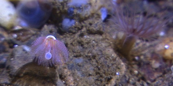
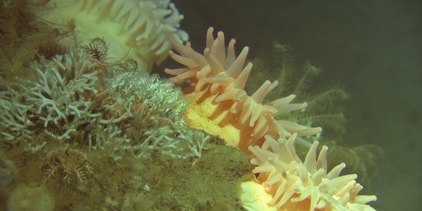
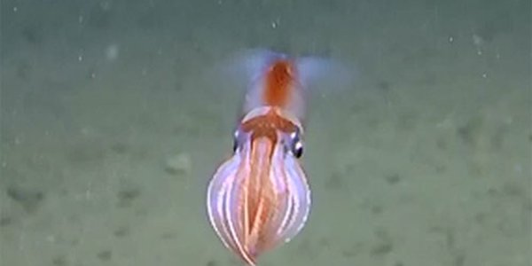
Apparently undisturbed by the light from the video rig, the little octopus "dances" in front of the camera at the Moskenes fishing ground off the Lofoten archipelago in northern Norway. It moves around in the water with small, almost transparent wings, while the rest of the animal has sharp colors. As most cephalopods, this species also has arms, ready to catch a passing prey.

marinelandscapes

The mid-Norwegian shelf: A fascinating landscape

22.02.2013

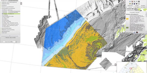
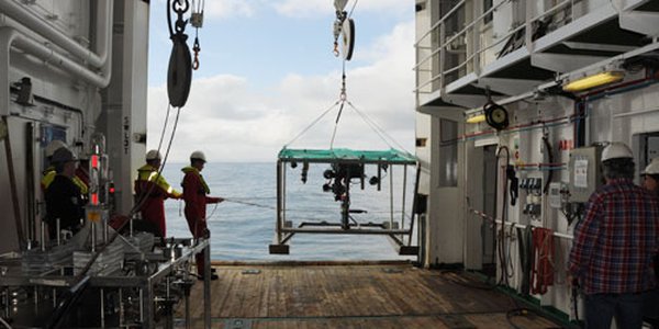
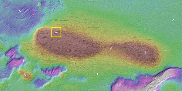
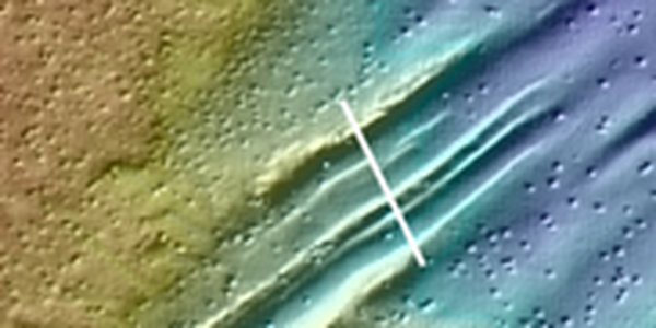
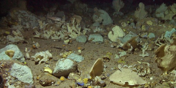
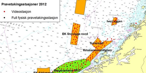
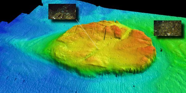
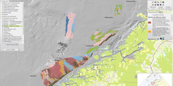
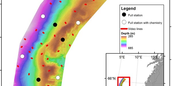
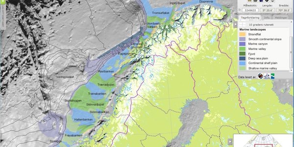
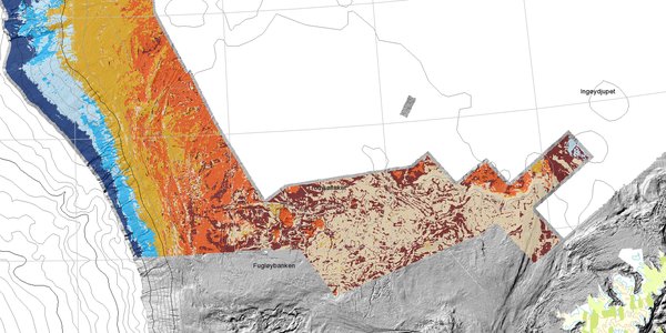
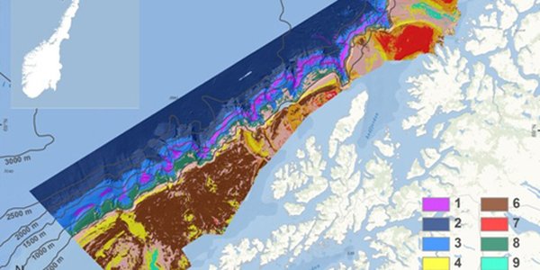
As the focus of the MAREANO programme moves southwards to the mid-Norwegian continental shelf, there is a large area of seabed to be mapped.

biotop tromsoflaket eggakanten stor

Updated biotope map published for Tromsøflaket-Eggakanten

22.02.2013

MAREANO’s map service now includes an updated map showing the predicted distribution of biotopes across the Tromsøflaket-Eggakanten region.

olex2 500 utsnitt2

Use of alternative bathymetry data in mapping

12.06.2012

As MAREANO extends into previously unmapped areas it is prudent to see if costs can be reduced by using alternative sources of bathymetry data, rather than full coverage multibeam data. A new report from the Geological Survey of Norway and the Institute for Marine Research tests out one possible source of alternative bathymetry data and evaluates the use of these data in future MAREANO work.

Kaldtvannskoraller

More coral reefs off the mid-Norwegian coast

11.12.2012

Cruise report: During the 2012 MAREANO autumn cruise, scientists onboard RV ”G.O. Sars” discovered 15 new coral reefs off the coast of Trøndelag and Møre and Romsdal counties.

Børstemark

Grant of 2.6 mill Nkr to identify new bristle worms

30.11.2012

An expert group has for several years been working to identify new bristle worm (Polychaeta) species in the MAREANO seabed samples. Recently, the Norwegian Biodiversity Information Centre, allocated 2.6 million Norwegian kroner (ca. 350.000 €), enabling further research on this material.

Vulkan

Ancient volcano on Mørebanken investigated

11.12.2012

Around 55 million years ago there was volcanic activity in the northeastern part of Mørebanken, offshore mid-Norway. Today we can find remains of this volcanism in the form of a steep sided column-like mountain rising from an otherwise fairly flat seabed, which now provides a home for a variety of fish and other bottom dwelling animals.

Kråkebolle (Pippip Ferner)

Guests on our expedition

11.12.2012

On this year’s autumn expedition, in addition to the usual mix of scientists and technicians, we had the pleasure of having two guests. They were the artist Pippip Ferner and the journalism student Silje Pileberg, who hoped to expand their horizons for the benefit of their own projects, while also shedding light on our research in ways that we would be unable to do.

Kaldtvannskoraller

Coral reefs revealed by acoustic imagery

10.10.2012

Cruise report: The Sula Reef area in mid-Norway is known to contain numerous coral reefs, but less is known about coral reefs outside the designated protection area where trawling is prohibited. During transit between the Iverryggen and the Sula reef marine protected area (MPA), we used the opportunity to look for new and undiscovered coral reefs.

Små kråkeboller

Walkabout at the seafloor

11.12.2012

Cruise report: While using a video-rig to map the biodiversity of the sea-bottom, we often observe animal tracks crossing the seafloor. Such tracks can be holes, mounds or traces that are a result of the animals’ movement. This last week we have seen many such very decorative tracks on the seafloor in the area of Sunnmørsbankene at around 200 m depth, and the amount and density of the tracks bear witness of quite heavy “traffic” in some areas.