Goto main content

News

Result: (5)

2017 05 kart 541 ny

New Nautical Chart on Svalbard

27.06.2017

A new chart covering waters north of Nordaustlandet, has been published. This main chart is named “no. 541 Nordporten–Sjuøyane”. MAREANO and the Norwegian Mapping Authority Hydrograophic Service surveyed the fairway to Rijpfjorden in 2016.

Muddersjostjerna paa havbunnen og ombord

In a Sea of Stars

07.04.2017

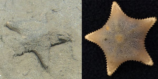
Mud Stars are important as they burrow down into the mud, helping to oxygenate the sediment and stimulating microbial growth, which contributes to nutrient cycling and release. They also feed on the organic matter present within the mud, hence the name Mud Star.

Barentshavet east nitall

MAREANO Live at the UN

28.03.2017

This Norwegian seabed-mapping program is a provider of knowledge for blue growth. Watch the live stream when MAREANO presents itself at the UN 28 March.

3d rygger spitsbergen 30 40m dyp meritaito 1m grid

Rich Formations on the Seabed of Spitsbergenbanken

11.01.2017

Now we are able to reveal how the landscape curves itself on the bottom of Spitsbergenbanken on Svalbard. In 2016, the Finnish firm Meritaito has been conducting bathymetric mapping on Spitsbergenbanken and in the Barents Sea, organized by the MAREANO programme.

Rijpfjorden

The Fairway to the Rijpfjord Surveyed

04.01.2017

– MAREANO has planned to survey the Rijpfjord in Svalbard in 2017 and 2018. Therefore, the fairway into this arctic fjord was surveyed in 2016, says Hanne Hodnesdal at the Norwegian Hydrographic Service.