Contact
Biological mapping
Børge Holte
+47 77 60 97 53
Geological mapping
Terje Thorsnes
+47 73 90 42 75
Bathymetry
Hanne Hodnesdal
+47 51 85 88 23
Information officer
Beate Hoddevik Sunnset
+47 55 23 85 16
Published: 10.10.2012 Updated: 27.11.2012
The research vessel G.O.Sars which is used for the MAREANO cruises is very well equipped for a range of purposes. The EM302 multibeam echosounder on board is suitable for mapping in a variety of water depths. During this MAREANO cruise we have used this multibeam extensively during transit between areas already mapped by the Norwegian Hydrographic Service in order to supplement regional bathymetry data from Olex AS. From the Olex data we could see that the main coral ridge in the Sula area continues northeastwards, and since corals could be seen in the EM710 multibeam data right up to the NE corner of the data we could't help but wonder if they continued along the rest of the ridge. During transit from Iverryggen to Sula, we therefore used the opportunity to acquire one line of multibeam data along this ridge, in order to check for the presence of coral reefs which have a distinctive shape that can be imaged with multibeam.
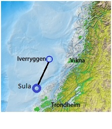
MAREANO cruise 2012110 acquires multibeam data during transit from Iverryggen to Sula, Mid-Norway.
New data acquired (upper right) reveals new and unknown coral reefs outside the Sula Reef MPA.
Close up view of the coral mounds at the NE corner of the Sula area where the new multibeam data meets the previously mapped area. The new data are slightly lower resolution and have not yet been fully processed however it is quite possible to see continued coral mound structures within the data. The main coral mound areas within the new data are indicated by black circles.
Sure enough, the new multibeam data indicate coral-like mounds along the ridge and surrounding seabed extending approximately 25 km northeast of the existing MPA boundary, though with lower densities than within the MPA. The presence or status of corals has not been verified here, however, the mounds are of the same form as those within the MPA. These additional multibeam data will be a useful extra result of this MAREANO cruise, providing information which may helpful in making management plans for the area, and for prioritizing future mapping efforts.