Investigating new heights in the deep
Published: 17.12.2025
While approaching the ridge, we discover seafloor spreading in action - marked by spectacular landscapes linked to volcanism.
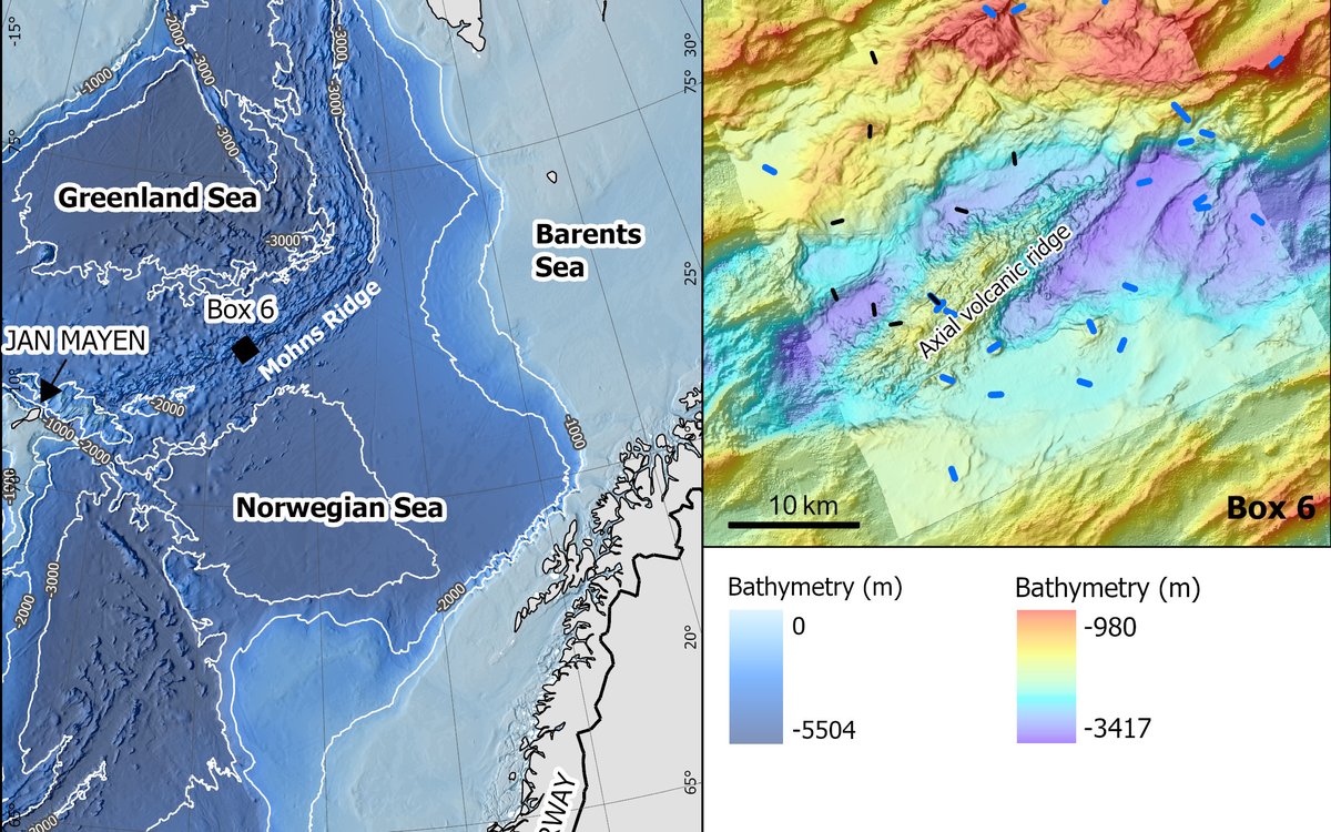
The first area we investigate (Box 6 – Figure 1B), lies along the Mohn’s Ridge; an ultra-slow spreading ridge with a sea floor spreading rate of less than 20 mm/year driven by magmatic activity. This slow spreading rate implies that the North Atlantic Ocean widens less than 20 mm per year during new crust formation in this area. In this special locality, we expect to find new substrates and subsea minerals with fascinating structures and landforms; and so far, we have not been disappointed. In the videos obtained by the remotely operated vehicle (ROV), we see a torn landscape made up of structures that are many metres tall or deep suddenly appearing in front of us. Considering that our bathymetry map is coarser than usual, these sudden and unexpected structures can easily be hidden from our view above.
Axial volcanic ridges, found at the centre of mid-oceanic ridges, are where most of the magmatic activity occurs in ultraslow spreading ridges. Every eruption helps in pushing the tectonic plates on each side of the volcanic ridge further apart. Basalt appears in large volumes and makes up most of the rocks we see during this cruise. In addition, we observe a lot of volcanic structures (Figure 2).
The spreading caused by volcanic activity on the ridge, leads to new crust formation and fractures known as faults as the plates continuously diverge. These faults are often parallel to the ridge and may cause the bedrock to shift vertically or horizontally. This creates impressive vertical walls that reach heights of several tens to hundreds of metres above the seafloor (Figure 2).
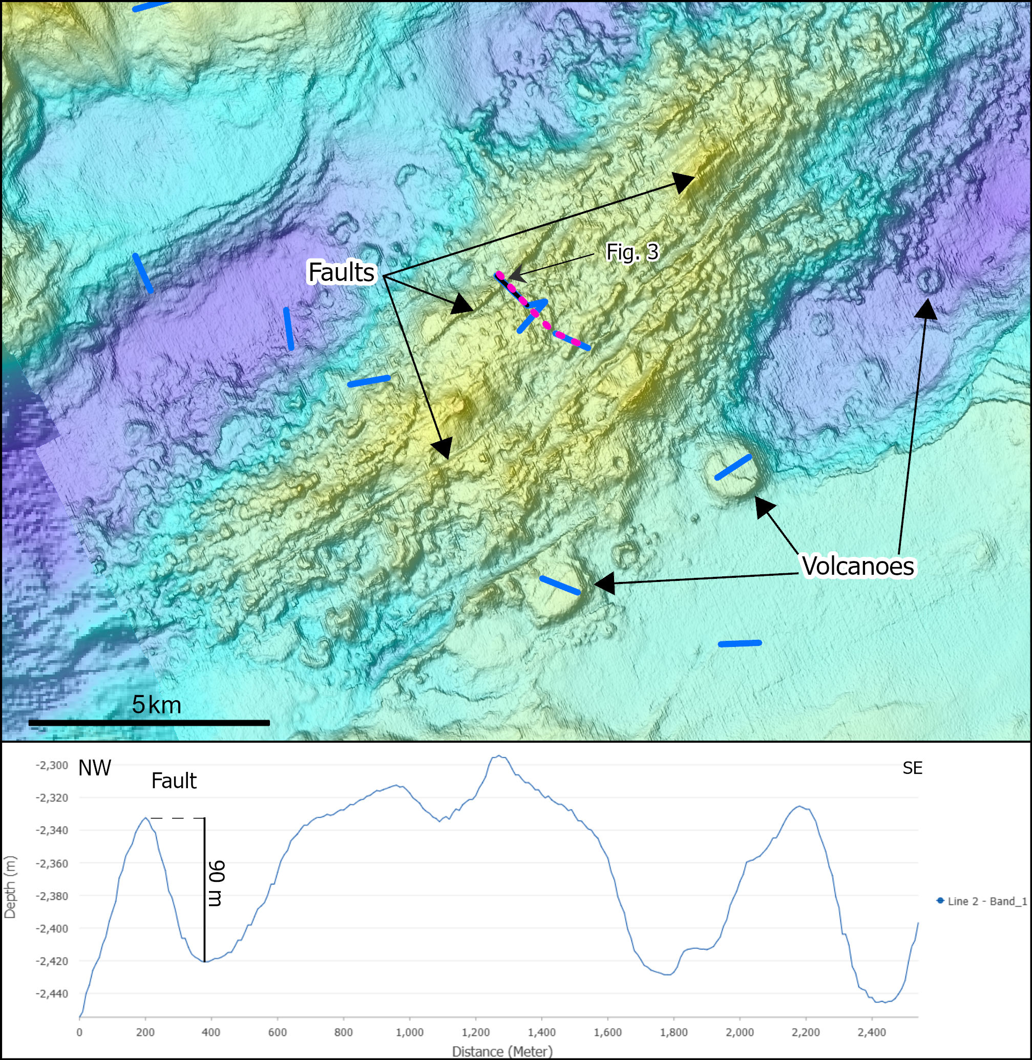
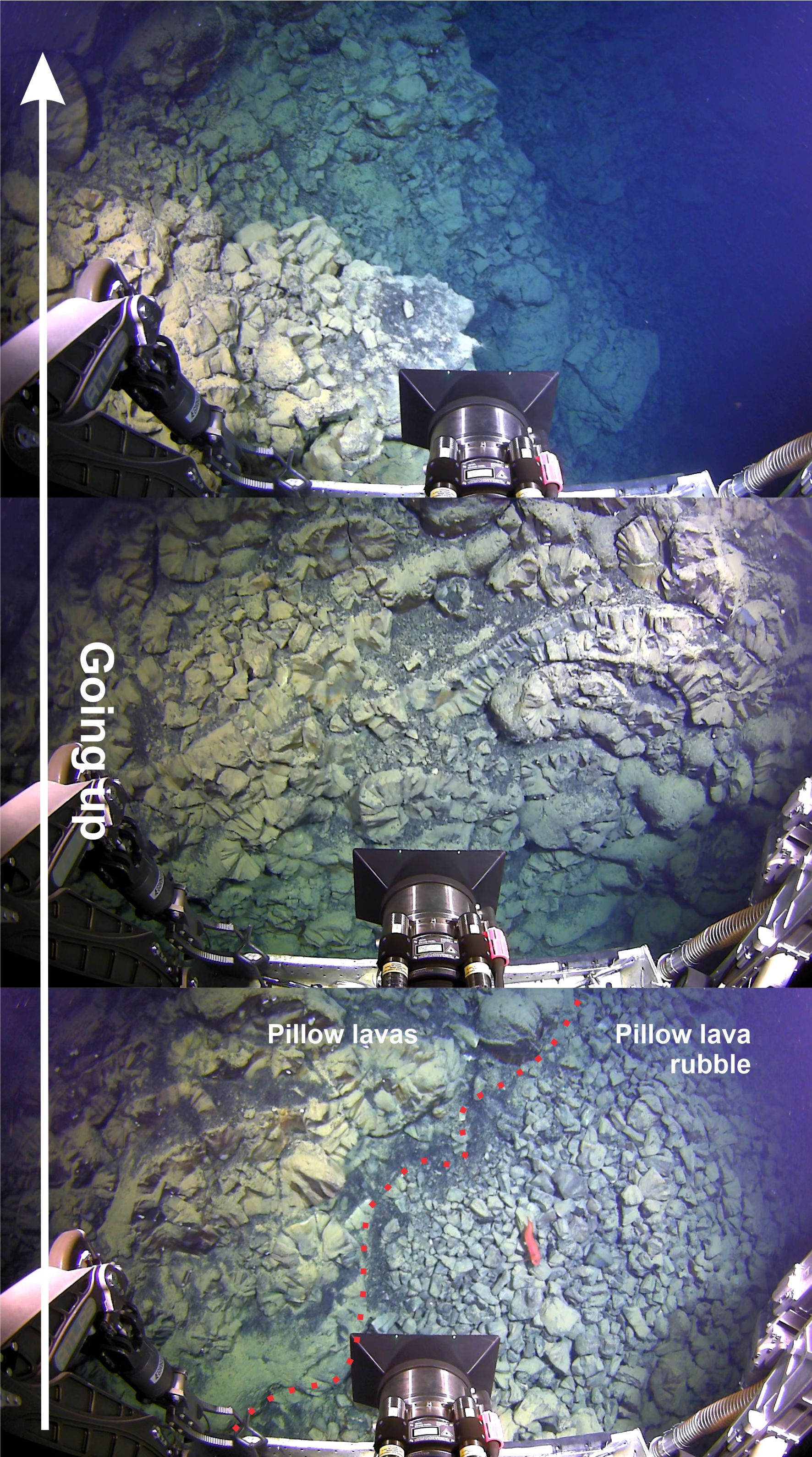
One video line crosses a 90 m high fault cliff within volcanic rocks (Figure 3). As the ROV moves up along the face of the cliff, we observe layer upon layer of basalt and pillow lavas, all which look like they have been violently torn apart. The movement and internal friction/crushing caused by the faulting has left behind rubble of broken pillow lava at the foot of the cliff (Figure 3).
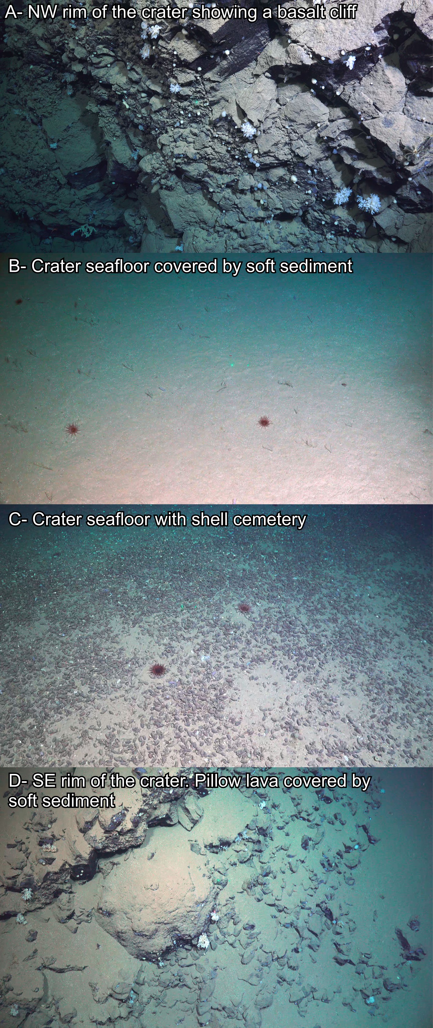
Volcanoes surround the axial volcanic ridge, with some also occurring along the edges of the main rift valley (Figure 4). They can be recognized as craters, but are also present as round, flat-topped elevated structures (arrowed in Figure 2). We investigated a volcano c. 500 m in diameter about 5km away from the ridge (Figure 4). In some videos, remnants of lava flows are visible around the rim of the volcano crater, often with different sessile invertebrates like sponges, crinoids, and anemones inhabiting the hard and soft substrate around the crater.
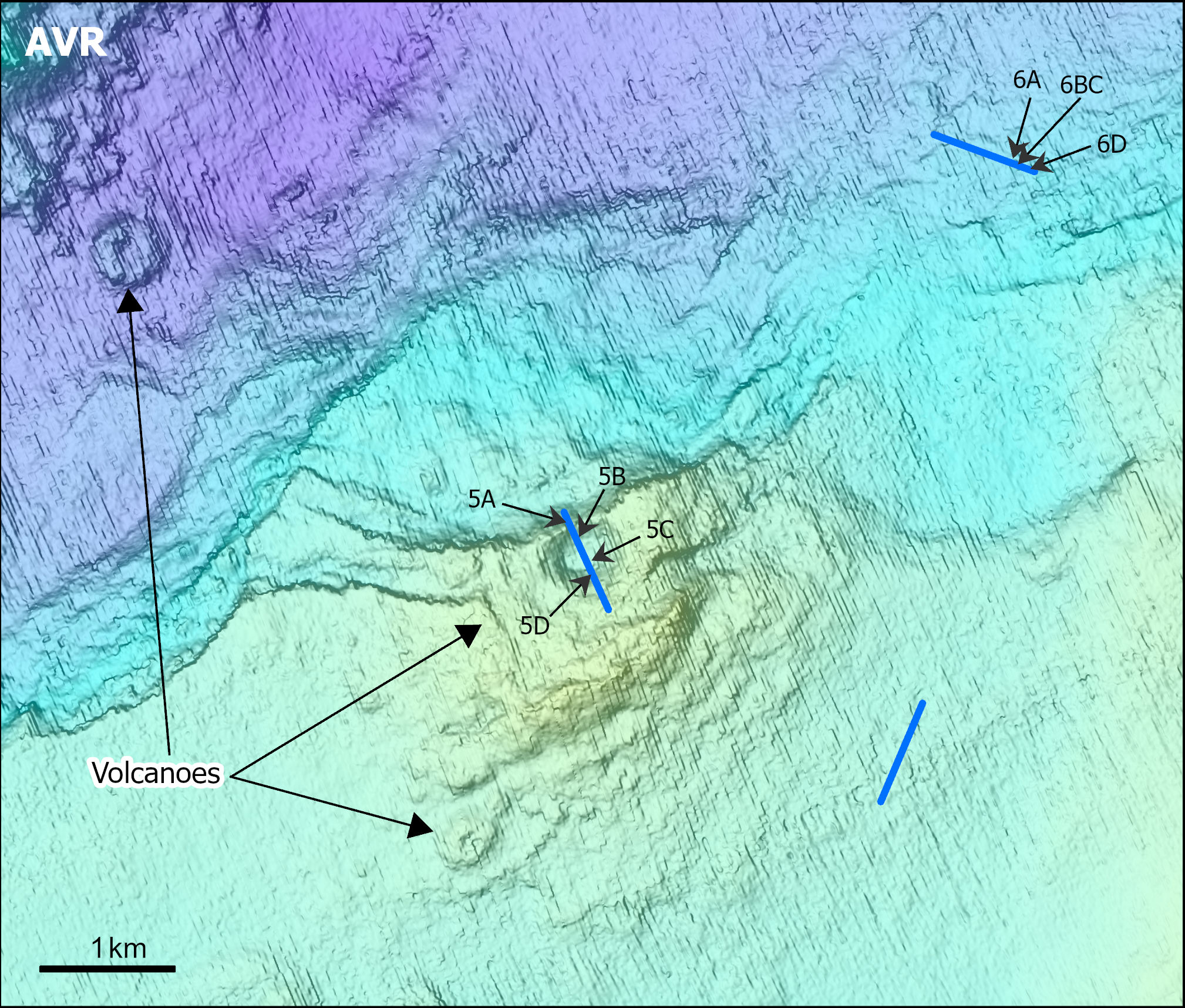
Smaller, interesting linear structures are also observed in several lines. They are elongated, with widths from less than 1 m to several tens of metres and depths up to several metres. The bottom of these structures is often too deep to be observed in the ROV videos. Due to their narrow width, they are not apparent on our bathymetry map, thus we do not know their depths or their extents. These thin and deep structures are known as fissures. Fissures are commonly the result of fault propagation but can also be related to cooling cracks. They may exhibit an offset and represent faults, with one wall higher than the other. Interestingly enough, we also noticed a lower abundance of the invertebrates settled around and in the fissures.
Figure 6. Examples of fissures. Some are very narrow (picture C) while others are much larger (picture D). In D we also see a block in the fissure. It is often not possible to see the bottom of the fissures due to their depths (picture A). Distance between green lasers: 9 cm. Location of the pictures on Figure 4. Video from ROV Ægir6000 (NORMAR).
But the cruise is not finished, and more interesting and exciting features will likely appear again in front of our eyes! To be continued…
Contact

Lilja Rún Bjarnadóttir
Geological Survey of Norway
Geological mapping
Geologist
944 97 728