Hanne Hodnesdal
Norwegian Mapping Authority, Hydrographic Service
Bathymetry
+47 51 85 88 23 / +47 47 31 72 22
Published: 19.05.2022 Updated: 20.05.2022
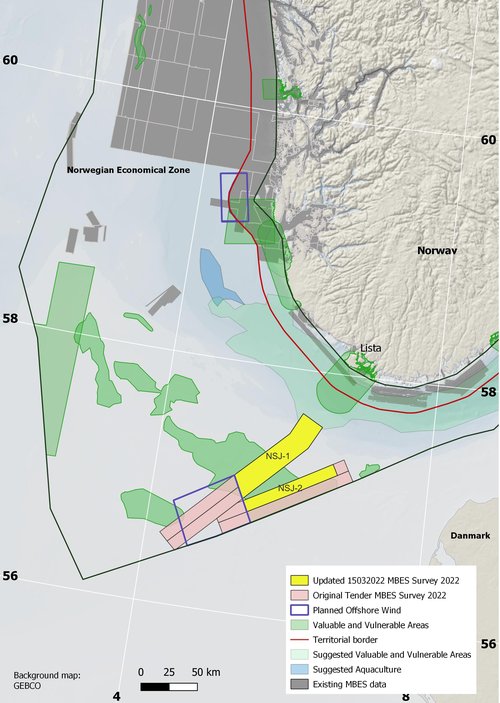
There will be conducted bathymetric mapping in the North Sea right next to areas considered relevant for offshore wind projects. This is a spawning area for the fish sandeel and is a so-called particularly valuable area in Norwegian waters (SVO).
– We hoped to survey an entire corridor in to the coast, but since Norskerenna is so much deeper than the area in the North Sea, the bathymetric mapping requires a different type of echo sounder. Therefore, the MAREANO programme has decided to stop right before Norskerenna, says Hanne Hodnesdal, head of MAREANO in the Norwegian Mapping Authority.
In March, the Clinton Marine Survey AB was assign the tender for the procurement of bathymetry data acquisition and processing for MAREANO in the North Sea this year. The open invitation to tender was published on Doffin and TED in January 2022.
The Ministry of Petroleum and Energy (MPE) has given the Norwegian Petroleum Directorate (NPD) an assignment to conduct surveys in connection with awarding acreage for offshore wind. The NPD has been tasked with planning and implementing a tendering process for preliminary surveys in the areas of Sørlige Nordsjø II and Utsira Nord, which were opened for applications for renewable energy generation about 18 months ago, NPD writes on its website. A tender has been published on TED by the NPD.
As a result, the MAREANO has re-prioritized areas in the North Sea where the programme will conduct bathymetric mapping in 2022.